Maps
The map component allows you to create maps in individual documents. The Dashboard Map displays combinations of map data from documents in the hierarchy (see Dashboard Map); map layer tags are used to organise how the combined data are displayed (see Map layer tags).
Important: Dataflow Map objects use coordinates based on the geographic coordinate system EPSG:4326 (WGS84 - World Geodetic System 1984).
When you click in a map, the Map tab appears on the ribbon (see Map).
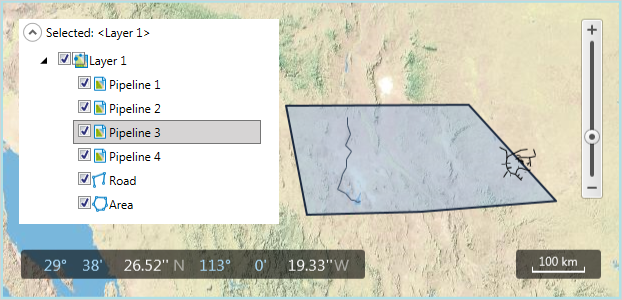
Map objects are structured by layers; the image below shows an example with one layer. You can draw points, lines and polygons, and import objects from shapefiles. In the image below, 'Pipeline 1' etc are objects from shapefiles, 'Road' is a Line (LINESTRING) object and 'Area' is a Polygon object. You can create as many layers and objects as required. To show or hide layers and objects, check or uncheck the boxes next to each layer or object name.

The Map Type, i.e. the type of map information shown in the background, can be changed by using the ribbon button or by doing right-click to open the context menu. The options are: Physical, Street, Shaded, Ocean, Imagery, Terrain Base, Topographic.
Documents store the currently-set position in the map, the selection, and the zoom level. Therefore moving around in a map, or zooming a map, will be registered as a change to the document.
Note: Objects imported from shapefiles are not shown in the Dashboard map.
Note: The Dashboard Map has a display limit of 500 map objects. POINT and POLYGON objects have a count of 1 with respect to this display limit, however LINESTRING objects are counted by the number of line pairs that are contained (e.g., a LINESTRING containing 10 points will be counted as 9 map objects), and hence the limit may cause issues. For closed LINESTRING objects (i.e., starting and ending at the same point) it is possible to substitute POLYGON objects. It is not currently possible to modify the 500 object display limit, but this will be added as a new setting in PlanningSpace version 16.5.
